Surveying by drones reduces time required for progress control of earthworks by 60%
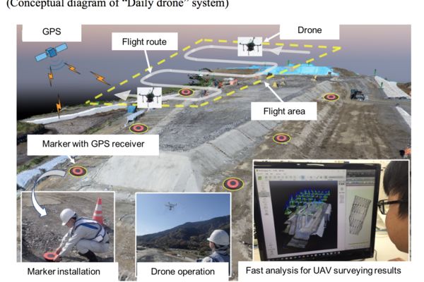
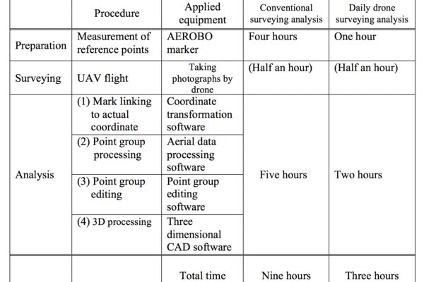
Fujita Corporation (Headquarter: Shibuya-ku, Tokyo. President: Yoji Okumura), a member of the Daiwa House Group, has developed a technology called "Daily Drone 1) " to utilize drones (Unmanned Aerial Vehicles) for daily progress control of earthworks, and the applicability of the technology to actual projects has been verified at one of our road construction sites. By deploying this technology, the time required for a series of works from "Control survey" to "Point cloud data analysis" can be reduced by 60% compared to our conventional methods. The technology can be easily applied any time that site engineers need to calculate soil volume. By utilizing the markers with GPS positioning function2) for the control survey, work time for a series of complicated process including installation of control points, surveying and inputting coordinate data can be reduced. In addition, when taking photographs by using drones, by setting necessary conditions (number of photographs, number of pixels, point group density and so on) to secure necessary precision, data size can be reduced and processing time can be greatly reduced.
1) Trademark registration has been applied for by Fujita Corporation
2) "AEROBOⓇ", a registered trademark by "Aerosense Inc."
Background of the development
Recently, high-performance and low-pricing drones are rapidly becoming widespread, and drones are being used for surveys before and after construction works as specified in the "i-Construction guideline" promoted by Ministry of Land, Infrastructure, Transportation and Tourism in Japan to increase construction productivity. However, there are several practical problems, and surveys using drones are not commonly utilized in daily surveying works during construction.
In conventional surveying using drones, installing control points (prepared in advance), surveying using "Total station" and point cloud data processing analysis after taking photographs involve significant amounts of time and money. Moreover, the control points, which are set by surveying, have to repeatedly be removed and set again depending on the progress of works. Recently, services to provide 3D models through internet browsers without using expensive high-performance PC and specialized software have become available. However, it takes a half a day for analysis processing, and the responsibility for handling as-built data when the work process is outsourced is unclear, and information communication environment of the sites in the mountainous region affects the work progress and data quality.
Applied technologies
The utilization of the "Daily Drone" puts emphasis on easy and prompt utilization of drones in the process of soil volume calculation and progress control at sites. Therefore, after daily construction works finish, drones are flown and all surveying processes (including processing of point cloud data after taking photographs and soil volume calculation) can be finalized within the same day.
This technology is developed as a summary surveying method to reduce work time for installation of control points and the reduction of work time for analysis processing of point cloud data. However, this method achieves the finished work shape precision with ± 50mm and soil volume calculation error within ± 5%. Moreover, when high-precision surveying is necessary, by modifying control setting in taking photographs, it is possible to attain the precision which is specified in the "i-Construction guideline".
Effects
By utilizing the "Daily Drone" in daily progress control, this technology greatly contributes to realization of optimum process control and improvement of productivity and quality in overall stages of earth works.
(1) Manpower for the surveying works and data processing works can be greatly reduced, because ground surveying for the progress control is unnecessary.
(2) Surveying by the "Daily Drone" can be made more cheaply and rapidly than ever.
(3) Surveys using drones can be made when construction machineries are moving.Consequently, the workload of site engineers in charge of surveying can be reduced.
(4) Compared to conventional drone surveying methods, totaltotal time between "Control survey" to "Point cloud data analysis" can be greatly reduced.
---
ENDS
---
Fujita Corporation
Public Relations Office
Tel. +81-3-3402-1911
Fax. +81-3-3404-8477
Email. info@fujita.co.jp