Development of a wild flora and fauna conservation management method in construction sites
Fujita Corporation (Headquarter : Shibuya-ku, Tokyo. President: Yoji Okumura), a member of Daiwa House Group, has developed a wild flora and fauna conservation management method for construction sites. Using this method, information on wild flora and fauna found at sites is recorded using GIS (Geographic Information System) through GPS-enabled mobile data terminals (such as smartphones) , and the recoded data is shared with relevant staff members online. By using this method, wild flora and fauna and their habitat are conserved effectively. The method has already been applied to a disaster restoration project in areas affected by the tsunami that followed the Great East Japan Earthquake on March 11, 2011, and the applicability of this method to take effective measures for conserving wild flora and fauna in construction sites was verified.
In the construction sites, due to land transformations and other reasons, construction works sometimes affect wild life habitats and the surrounding ecosystem. Usually wildlife at the sites are investigated before construction works start. However, the existence of wildlife cannot be perfectly identified because the emerging seasons for the various flora and fauna are different. In addition, site staff in charge of investigations sometimes lack the knowledge of wildlife and it is difficult for them to identify the appearance positions precisely if they don't properly mark and record the positions. On the other hand, if the investigations are handled by specialized contractors, the investigation cost is usually very high. For these reasons, effective low-cost implementation of conservation measures suitable for wildlife and construction sites are needed.
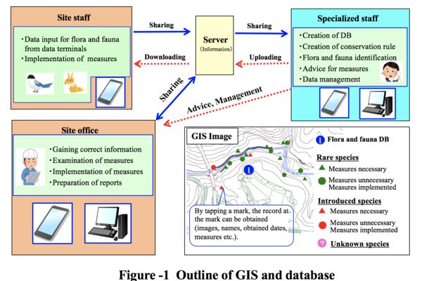
The method developed uses an online GIS which shows information on wild flora and fauna (names, appearance positions, inhabiting situations, necessity of conservation measures and specific measures, images etc.) on topographic map or satellite images. Using this method, data obtained at the construction site is transmitted and recorded on a server via mobile data terminals with GPS function. In addition, site staffs can access online to the GIS and related database showing necessary basic information on environment conservation such as "Environment conservation rulebook" 1) , and promptly share and complement necessary information with specialized staff as shown in Figure-1.
This method has been applied to the river disaster restoration project at the Minamiteizan area (Client : Miyagi Prefecture) to take environment conservation measures. In this project, existence of 182 types of birds, benthos, plants (including three types of plants, nine types of birds and five types of benthos as rare species) were identified. As a result, it is confirmed that appearance points of species in the Tsunami disaster areas can be identified and recorded with high accuracy. In addition, detailed examinations on selections of construction methods for conservation of wild flora and fauna were made considering the construction site situation and construction items,
In the future, this method will be used not only in construction sites (where conservation of wild flora and fauna is important) and for monitoring of biotope, but also for environmental educations of workers. Through these activities, Fujita Corporation will continuously make efforts for protection of natural environment and conservation of biodiversity in construction sites.
1) Environment conservation rulebook
A document describing followings;
- Rules for environment conservation which should be kept at construction sites
- Identification manual for rare species and alien species
- Necessary measures when these species are found at the sites in terms of environment conservation
---
ENDS
---
Fujita Corporation
Public Relations Office
Tel. +81-3-3402-1911
Fax. +81-3-3404-8477
Email. info@fujita.co.jp